czwartek, 17 grudnia 2015

QUIZ 1

UPDATE: IT ALL SHOULD WORK NOW. I EXTENDED THE FINISH DATE TILL MIDNIGHT, WEDNESDAY, DECEMBER 23.


GUYS, THERE'S A GLITCH - THAT'S WHY YOU CAN'T LOG ON. I'M WORKING ON IT. IT SHOULD BE ALL RIGHT IN THE AFTERNOON.

I'LL GIVE YOU TWO EXTRA DAYS TO COMPLETE THE QUIZ.


PLEASE GO HERE TO LOG IN AND TAKE THE QUIZ.

You will see such screen:


When you click on it, you'll see this menu:


Click "Take" and this page will open:


Click. Then read all the instructions REALLY CAREFULLY. Click START.


Remember to read instructions to each question. In some only ONE answer is correct. (You have to mark only one little circle).

Some questions require you to mark ALL answers which are correct (more than one) - you have to put ticks in little squares.


1. You have THREE attempts. If your computer crashes or you log out, you lose that attempt.
2. The quiz is active till Sunday 20th, midnight.
3. At the end you will be able to see a review of all your attempts. PRINT OUT the one with the highest score you got and bring it to the class.

wtorek, 15 grudnia 2015

Sepoy Mutiny

A good analysis of the reasons for the revolt is presented HERE.

If someone prefers a video format, have a look at this clip:


OK, I know it's a complex topic, so HERE is a little cheat - a good summary in Polish.

wtorek, 8 grudnia 2015

The British in India - part 1

We'll be talking about the British East India Company, but watch this video to learn more about trade and the presence of the Dutch in this region.

Remember that Crash Course videos have English subtitles - so you can switch them on if John Green speaks too fast ;)


wtorek, 24 listopada 2015

A timeline of British monarchs

Just to refresh your memory:


Pirates!!! Arrrhhh!!! And the Queen Anne's War in the background.

How come England has (had) so many little islands all over the world? Let's find out - at least where they came from in the Caribbeans.


Among all real and fictious pirates, Blackbeard is probably the most interesting one:


And to get some taste in what it was like to be a pirate, let's visit an interactive National Geographic page - but remember, it's kiddies website ;)

Go HERE for a bit more serious take.

wtorek, 17 listopada 2015

Atlantic Slave Trade

These are the videos we watched in class:


And the full lesson with an online quiz and additionla information can be found HERE.

The details of the main two "triangles" are explained in the clip below:


And this is a lesson from our old friends over at Crash Course. Remember that you can click on CC to get the English subtitles ;)

środa, 4 listopada 2015

wtorek, 27 października 2015

The age of exploration (15th and 16th century)

Worldwide exploration wouldn't have been possible without technological advances. Below you will find a presentation which discusses the most important ones.


(source: Prezi, author: Nicholas Chechlak)

A great follow-up is this article on Empires and Technology.

Starting in the 15th century advancement’s in methods of transportation and an increase in demand of goods from India sparked what is know as the Age of Exploration. Faster and less dangerous routes of trade, mainly with India, meant that merchants could make more money from gold, silver and spices. During this time European explorers found great new vast of land including North and South American as well as Australia. Modern methods of ship building made it possible for the European countries to begin colonizing these newly found areas and establish trade with them.


The Infoplease website has a very interesting Q&A on exploration.
==============================================
Back-up copy - the content of the passage belongs to Dorling Kindersley. No breach of copyright intended. For educational purpose only.

Copyright © 2007 Dorling Kindersley
People have always set out to discover new lands and oceans. The greatest age of world exploration began in the 15th century and lasted over four centuries. The Arabs and Chinese had already made improvements in ship design and NAVIGATION. These were now developed further by European seafarers.
Table 46. EXPLORATION
1405–1433Chinese fleets explore the Indian Ocean
1486Diaz rounds southern Africa
1492Columbus reaches the Caribbean
1497John Cabot reaches Canada
1498Columbus reaches South America
1498Vasco da Gama sails to India
1500Pedro Cabral reaches Brazil
1522Magellan’s crew sails around the whole world
1606Willem Jansz reaches Australia
POINTING THE WAY
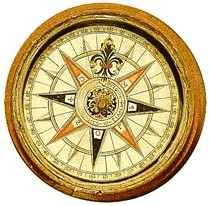
This type of mariners’ compass first came into use in about 1250. This one dates from the 16th century.

WHY DID PEOPLE EXPLORE THE WORLD?

The most common reason was trade. The OLD WORLD wanted Asian spices, African ivory, and gold. European traders were soon also seizing lands and trying to convert the local populations to the Christian faith. Many explorers, though, were driven by a sense of adventure or scientific inquiry.

HOW DID EXPLORATION AFFECT THE WORLD?

European countries brought many lands under their control. The world was opened up and new crops were introduced from one land to another. However, there were some disastrous effects. In the NEW WORLD, many native peoples died because they had no resistance to the European diseases that explorers and crews brought with them.

OLD WORLD

Europe, Asia, and Africa had been known to geographers since ancient times. They became known as the Old World after the European discovery of the Americas.

WHO EXPLORED THE OLD WORLD?

In the Middle Ages, the Venetian Marco Polo and the Moroccan Ibn Battutah traveled east to China. The Chinese admiral Zheng He sailed west to Africa in the 15th century. By the 16th century, Portuguese and Dutch ships were trading in southeast Asia.

NAVIGATION

Navigation is any method used to find one’s way or hold a ship on course. Sailors of the 16th century had various kinds of instruments to help them cross the oceans.

WHAT INSTRUMENTS WERE USED?

Sailors used a compass to see which direction they were traveling. They could also work out a ship’s position by measuring the angle of the Sun or stars above the horizon. They did this with a metal plate called a quadrant, a disk called an astrolabe, or a simple stick called a cross-staff.

HOW WAS DISTANCE MEASURED?

Distances traveled at sea were calculated from speed and time. To measure these, a wooden log was thrown overboard. The crew called out the time it took for the log to pass between two measuring points on the ship. The ship’s course and progress were measured on a pegboard.

BIOGRAPHY: HENRY THE NAVIGATOR 1394–1460

This Portuguese prince founded an observatory and a school of navigation on Cape St. Vincent, Portugal. Here, a new type of ship, called a caravel, was designed. Henry also sponsored voyages along the coast of West Africa.

NEW WORLD

“New World” was one of the terms that came to be used by Europeans to describe the newly discovered lands of North and South America.

WHY DID COLUMBUS SAIL WEST?

In 1492, Christopher Columbus persuaded King Ferdinand and Queen Isabella of Spain to sponsor a voyage westward. The goal was to find a new trading route to Asia. Columbus landed in the Bahamas, starting a new age of exploration and invasion.

(source: http://www.infoplease.com/dk/encyclopedia/exploration.html )
=================================================


Next week we will be talking about the Triangular Trade, so please study the text on
European maritime adventures: 1402-1460

Island communities before European exploration

Maori are another group who evolved their society in isolation, even though they settled New Zealand relatively late (hence the nickname of NZ - "the youngest nation on Earth").

Below you will find a very informative presentation from Prezi.


*
**


środa, 21 października 2015

Pre-colonial period: Africa and India

Here's the video we watched in class. It summarises the main differences between isolated and connected societies and main benefits/drawbacks.


Africa is a curious place. On the one hand the continent IS connected to Europe and Asia, and indeed some exchange between nations did happen (especially in the northern and north-eastern parts), but its geography, climate and sheer size isolated many of its main ethnic groups and forced them to evolve in (partial) isolation.

This is the presentation we had in class:


The two maps in larger sizes: MAP 1 and MAP 2

India on the other hand fully benefited from its closeness to Mesopotamia in the west and China in the east. The Hindu evolved into a well balanced society with its vibrant culture and advanced science. Three religious systems had laid the basis for that civilisation before it came into contact with the British: Hinduism, Buddhism and Islam.

The video below shows the impact of Hinduism on social classes, but it also provides information about the beginning of the Hindu India society and its technical advances. You are welcome to watch the entire clip, but the obligatory watching are only parts 1 and 3.


Part 1: 1:35-3:55, 5:10-5:30 
Part 3: 8:45-12:13

środa, 14 października 2015

Timeline - part 1


Pre-colonial period: Aboriginal Australians and American First Nations

Introductory information. This is the presentation we had in class today.


This presentation was originally written by IJO graduates Magdalena Waligóra and Marcin Piechnik, I just updated some content. The copyright belongs to them and the owners of visuals used in this presentation. All sources have been cited.

Follow up watching.
These two brilliant docos will give you more information on the way of life of Canadian First Nations and Australian Indiginous people.


Extra reading: AUSTRALIAN INDIGENOUS CULTURAL HERITAGE